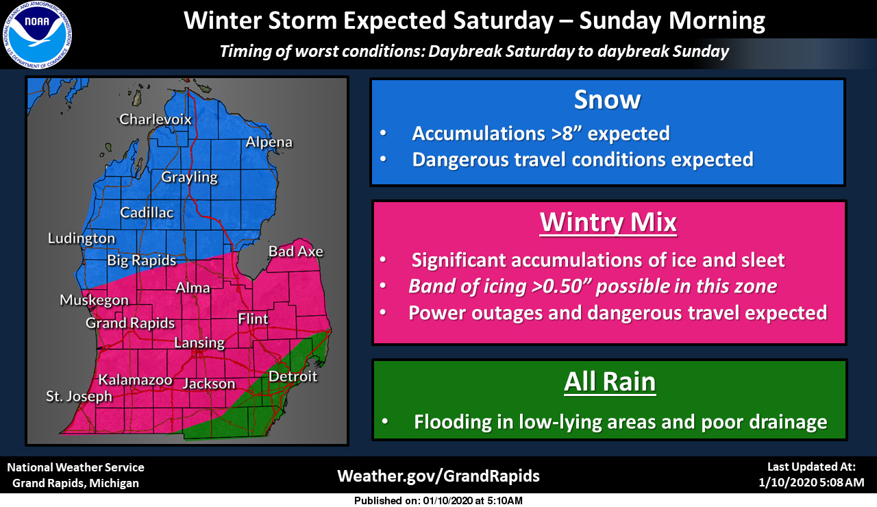
The National Weather Service is predicting a massive storm across the Midwest this weekend.
In Michigan, a variety of snow, freezing rain, and flood warnings have been issued, and are in place from 10 p.m. Friday until 10 p.m. Sunday. That could mean widespread power outages, downed trees and wires, and difficult traveling conditions throughout the state.
The northern half of the state should expect over 8 inches of snow, and the southeastern corner of the state is a under a flood warning due to heavy rains. The majority of the state is set to be hit with a nasty wintery mix, resulting in heavy ice cover.
Officials are warning people to be prepared for power outages by having flashlights, extra batteries, and a 72-hour supply of food, water, and medicine available to your family and pets. Michiganders are cautioned to drive slowly, and carry a winter survival kit in their cars at all times.
You can check the DTE or Consumers' Energy outage centers for the latest information on power outages.
Here's what each region can expect this weekend:
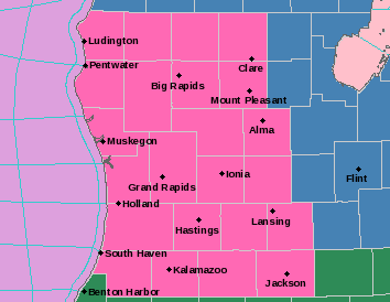
West/Central Michigan
There is a winter storm warning for the region including Grand Rapids, South Haven, Jackson, Lansing, Clare, and Ludington. Snow and sleet accumulations of 3 to 10 inches and ice accumulations of one tenth to three tenths of an inch are expected. Northeast winds will gust as high as 40 mph.
The heaviest snow is expected north and west of a line from Whitehall to Clare, with mostly sleet and freezing rain southeast of that line.
East Michigan
There is a winter storm watch and flood watch in Huron, Saginaw, Tuscola, Sanilac, Shiawassee, Genesee, Lapeer, Livingston, and Oakland Counties. Freezing rain producing ice accumulations around half an inch possible. Sleet and snow may mix in at times, mainly north of I-69, but just light accumulations, if at all. Winds could gust as high as 40 mph, which may further increase later Sunday morning.
Southeast Michigan
There is a flood watch in Genesee, Lapeer, Lenawee, Livingston, Macomb, Monroe, Oakland, Shiawassee, St. Clair, Washtenaw, and Wayne counties. Heavy rain is expected to begin Friday night, with total amounts in the 2 to 3.5 inch range expected. Thunderstorms are expected late Saturday night, and a there is a possible transition into freezing rain Saturday.
There is also a lakeshore flood advisory for Macomb County.
The city of Detroit released a statement Friday morning saying crews are cleaning out storm drains to help reduce potential flooding, and is requesting citizens and businesses do the same.
Northern Michigan
There is a winter storm watch for the northern part of the state, including Traverse City, Gaylord, Alpena, Houghton Lake, and the eastern half of the Upper Peninsula.
Total snow accumulations of 6 to 11 inches and ice accumulations of around three tenths of an inch possible. Winds could gust as high as 40 mph.
West Upper Peninsula
Moderate to high amounts of light, fluffy snow are expected for the area including Marquette, Houghton, Iron Mountain, Menominee, and Ironwood. Winds as high as 35 to 40 mph are also expected, and could cause driting snow, minor lakeshore flooding, and beach erosion.
Want to support reporting like this? Consider making a gift to Michigan Radio today.
"Big" - Google News
January 10, 2020 at 11:18PM
https://ift.tt/2tLsyG3
A big winter storm is set to hit Michigan this weekend. Here's what you need to know. - Michigan Radio
"Big" - Google News
https://ift.tt/2OUhyOE
Shoes Man Tutorial
Pos News Update
Meme Update
Korean Entertainment News
Japan News Update
No comments:
Post a Comment